National Oceanic and Atmospheric Administration · 航天照片图库

National Oceanic and Atmospheric Administration · 航天照片图库,仅列出本次快照中实际生成且可访问的资料。

资料最后更新时间:

集合条目总数
86
当前页码
2
National Oceanic and Atmospheric Administration · 航天照片图库:共收录 86 项实际生成的公开资料,本页为第 2 页,共 2 页。
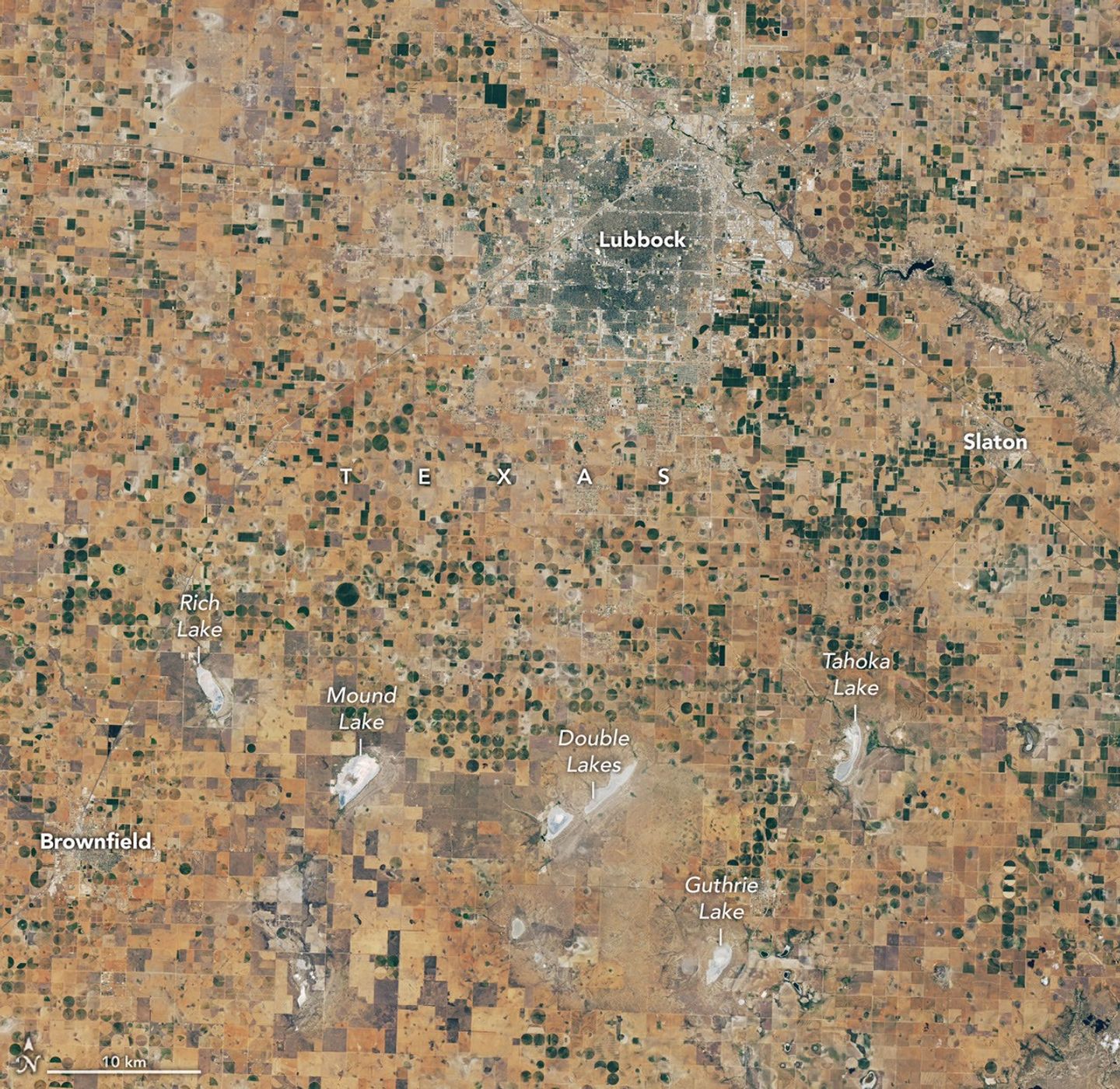
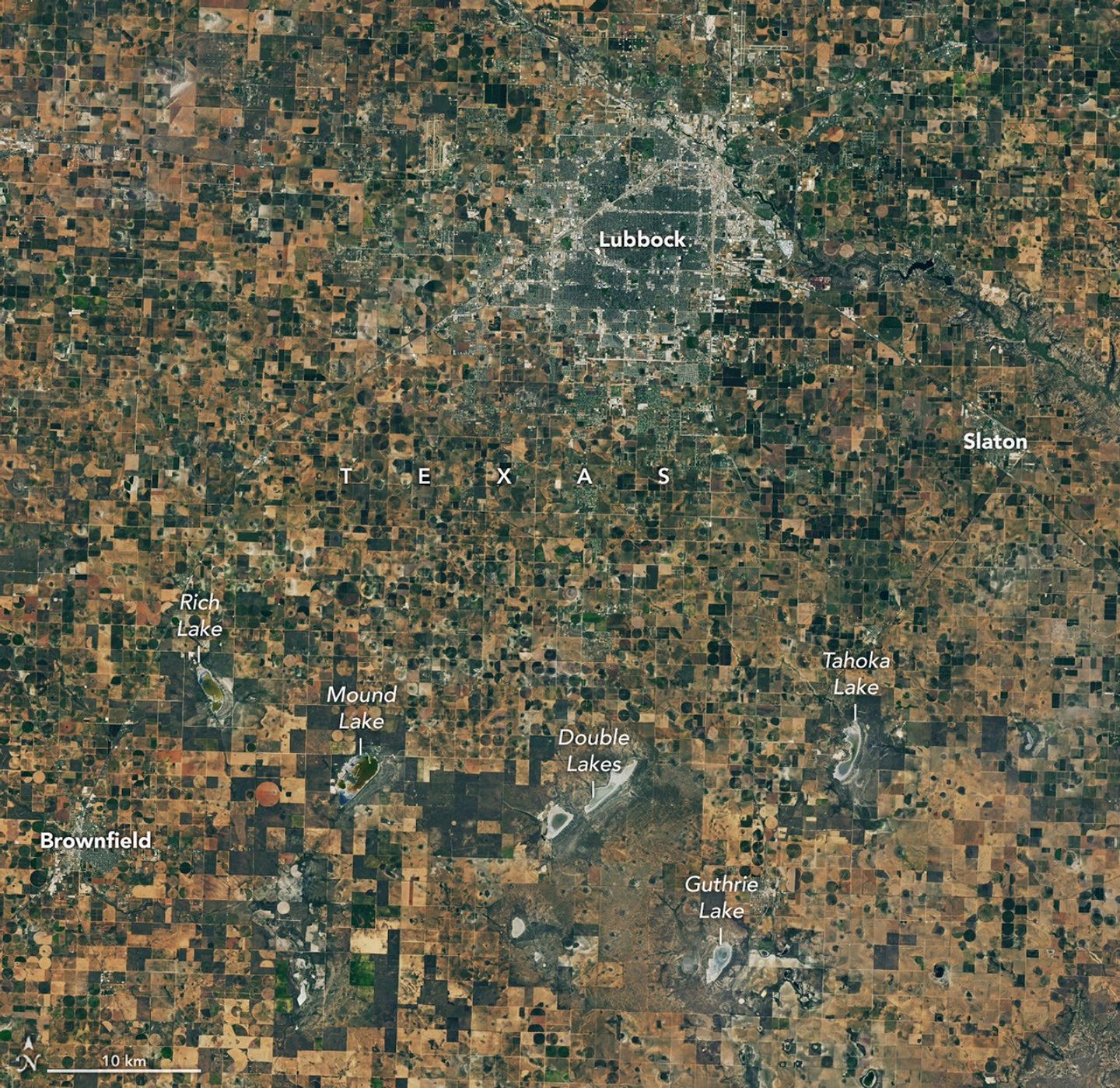
航天图片资料 · A satellite image of farmland around Lubbock, Texas, on September 22, 2025, features a patchwork of green and brown agricultural fields and several playa lakes with varying amounts of water.
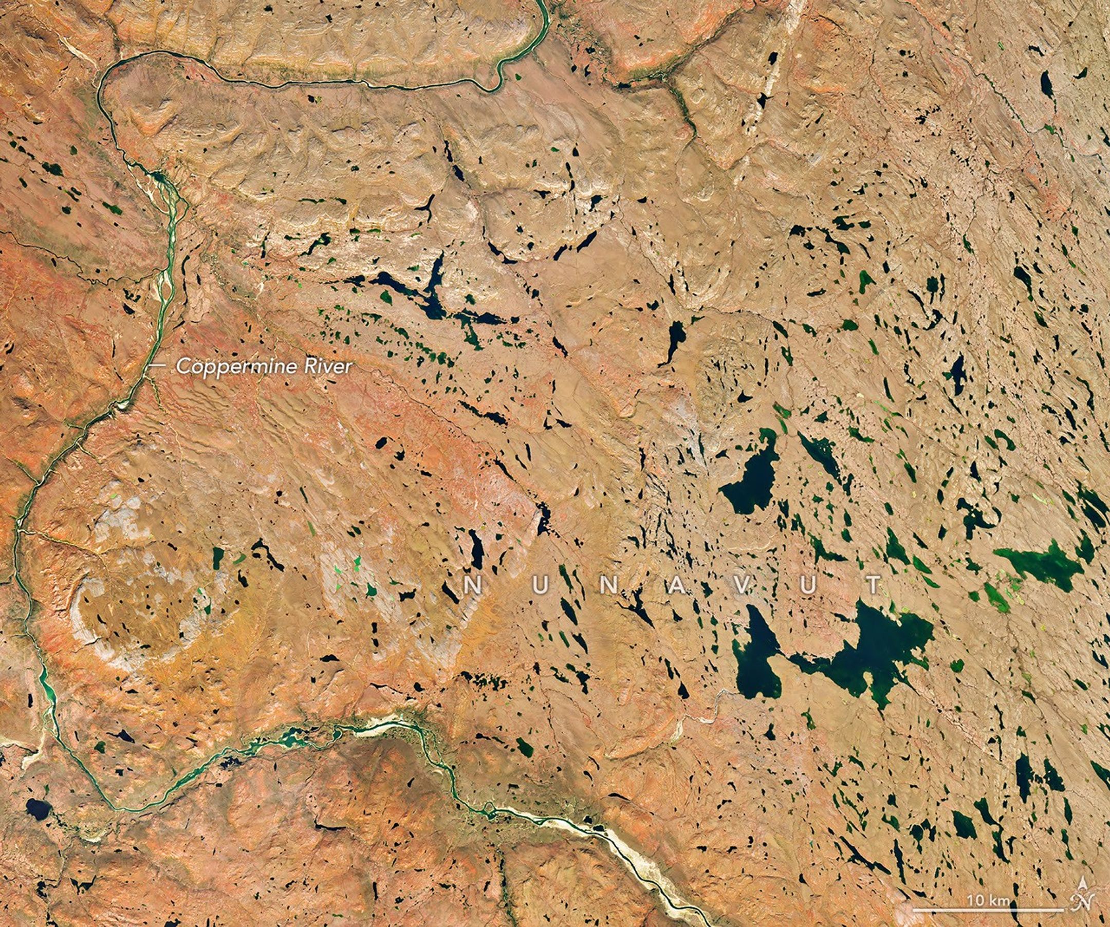
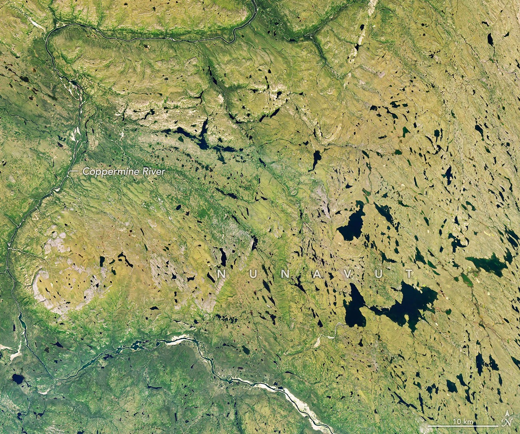
航天图片资料 · A river winds through a mostly green tundra landscape in summer, dotted with numerous lakes.
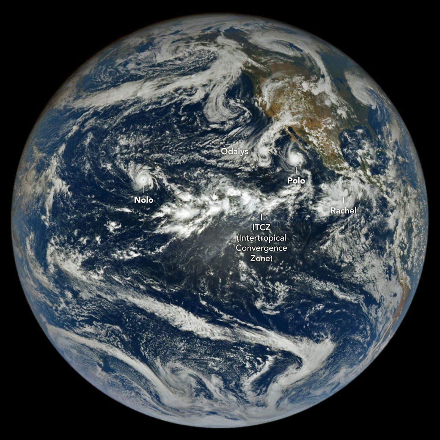
航天图片资料 · In a full-disk satellite view of Earth, several tropical cyclones swirl above the blue waters of the Pacific Ocean.
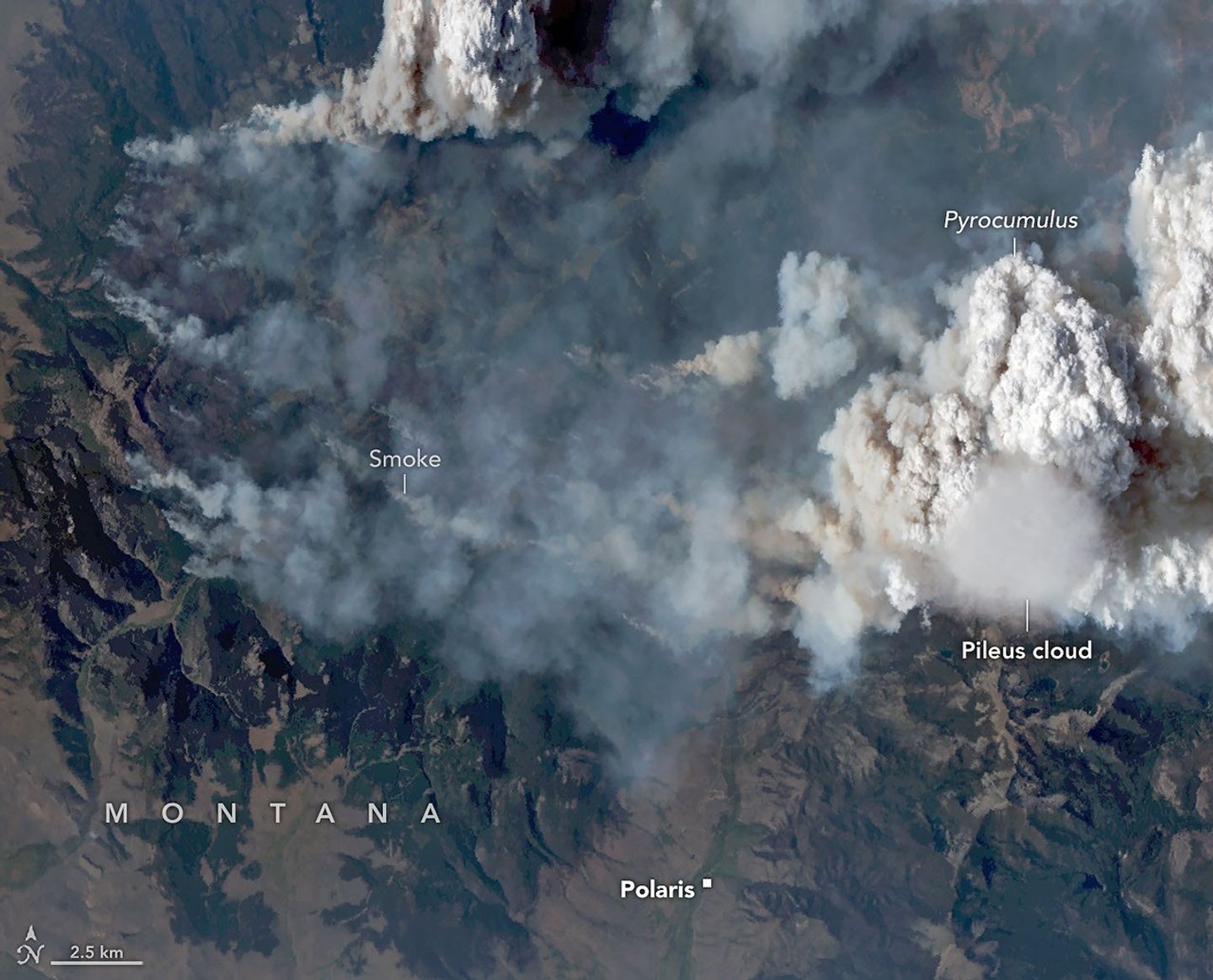
航天图片资料 · Natural-color aerial image of a wildfire in mountainous terrain. Thick gray and brown smoke spreads across much of the landscape, while a towering white pyrocumulus cloud rises at right. A smooth, thin pileus cloud hovers just below the main convective cloud.
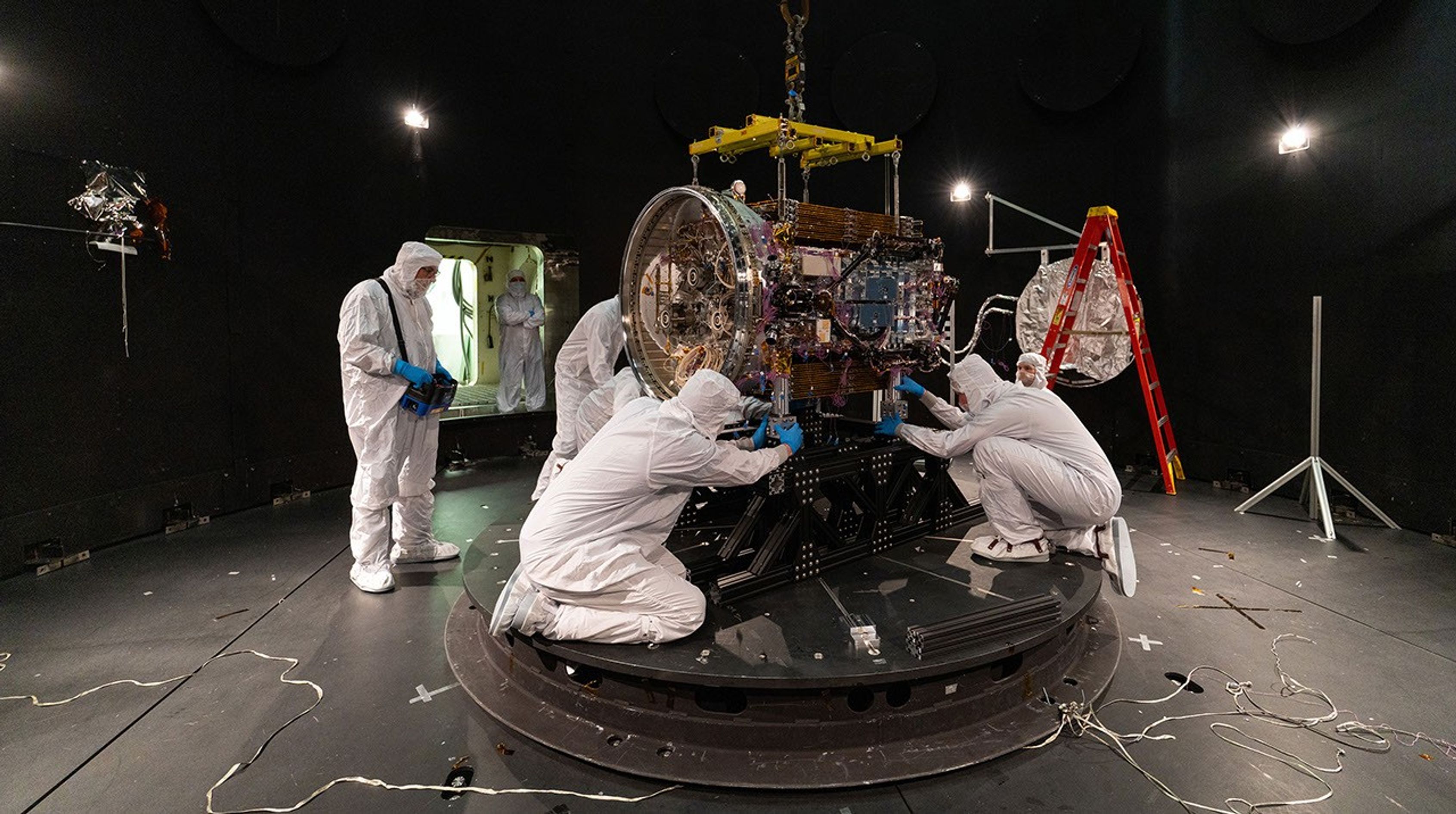
航天图片资料 · People in clean suits work on a spacecraft in a large chamber.
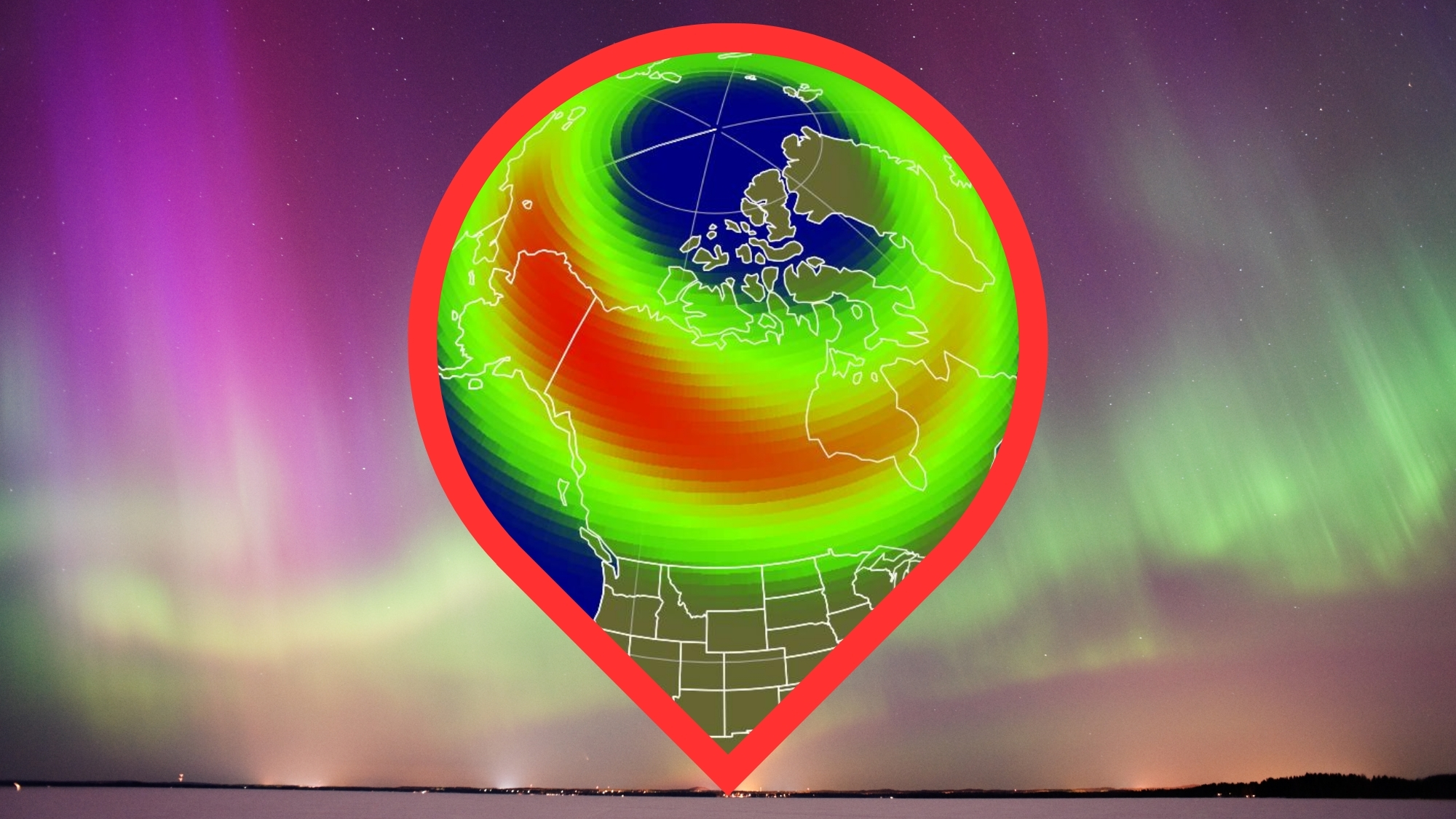
航天图片资料 · map showing the possible visibility of the northern lights over the US. in the background are vivid green and magenta auroras.
航天图片资料 · A river winds through the same tundra landscape in autumn, now colored red and orange. Some green vegetation remains visible along the river.
航天图片资料 · Smoke covers much of the southern third of New Guinea, while clouds and east-west-running mountain ranges are visible in the northern part of the island.
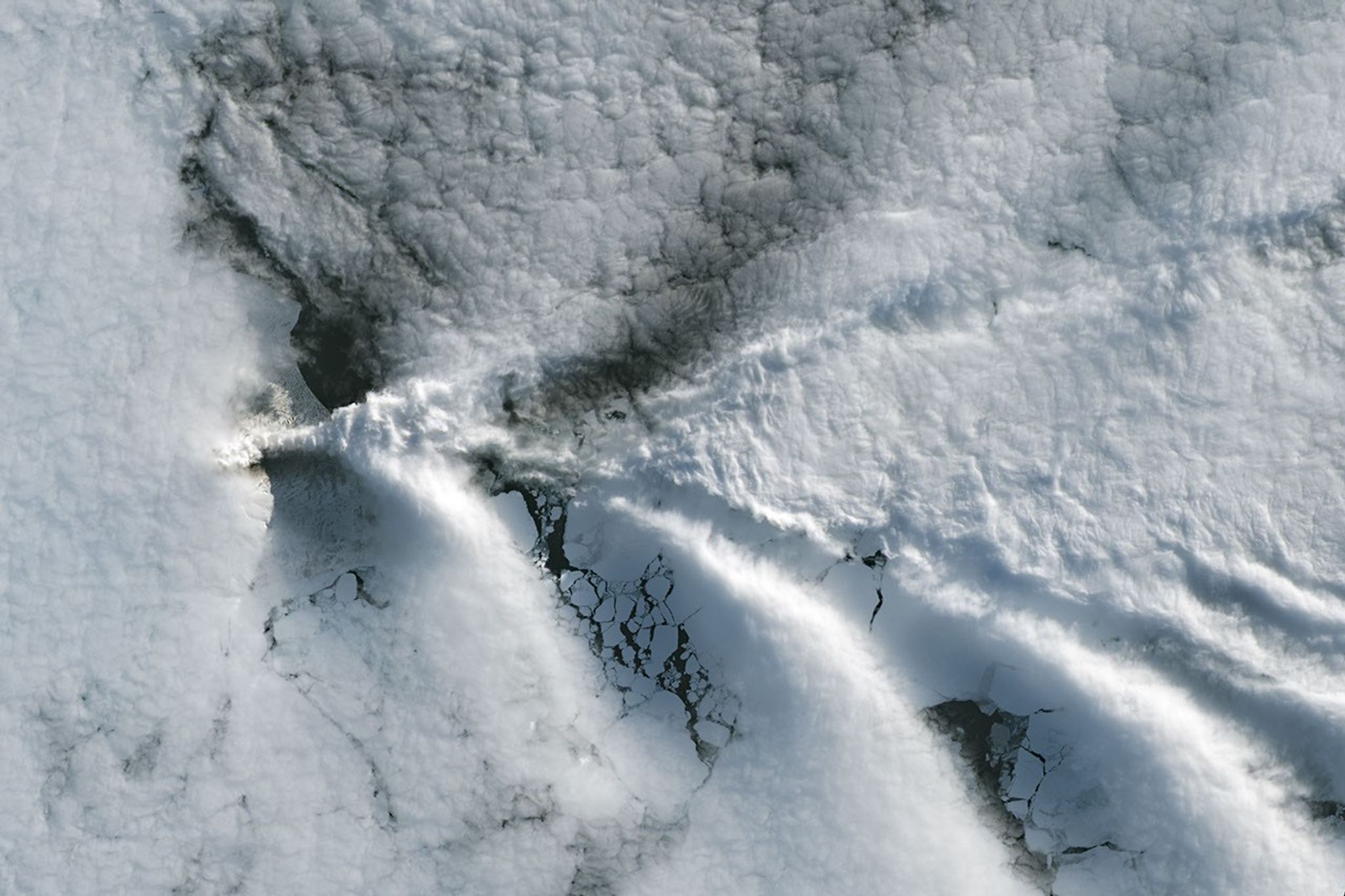
航天图片资料 · A series of V-shaped wave clouds appears over an ocean filled with pieces of sea ice.
航天图片资料 · NASA Adds Relativity Space's Terran R to Launch Services Contract NASA ©
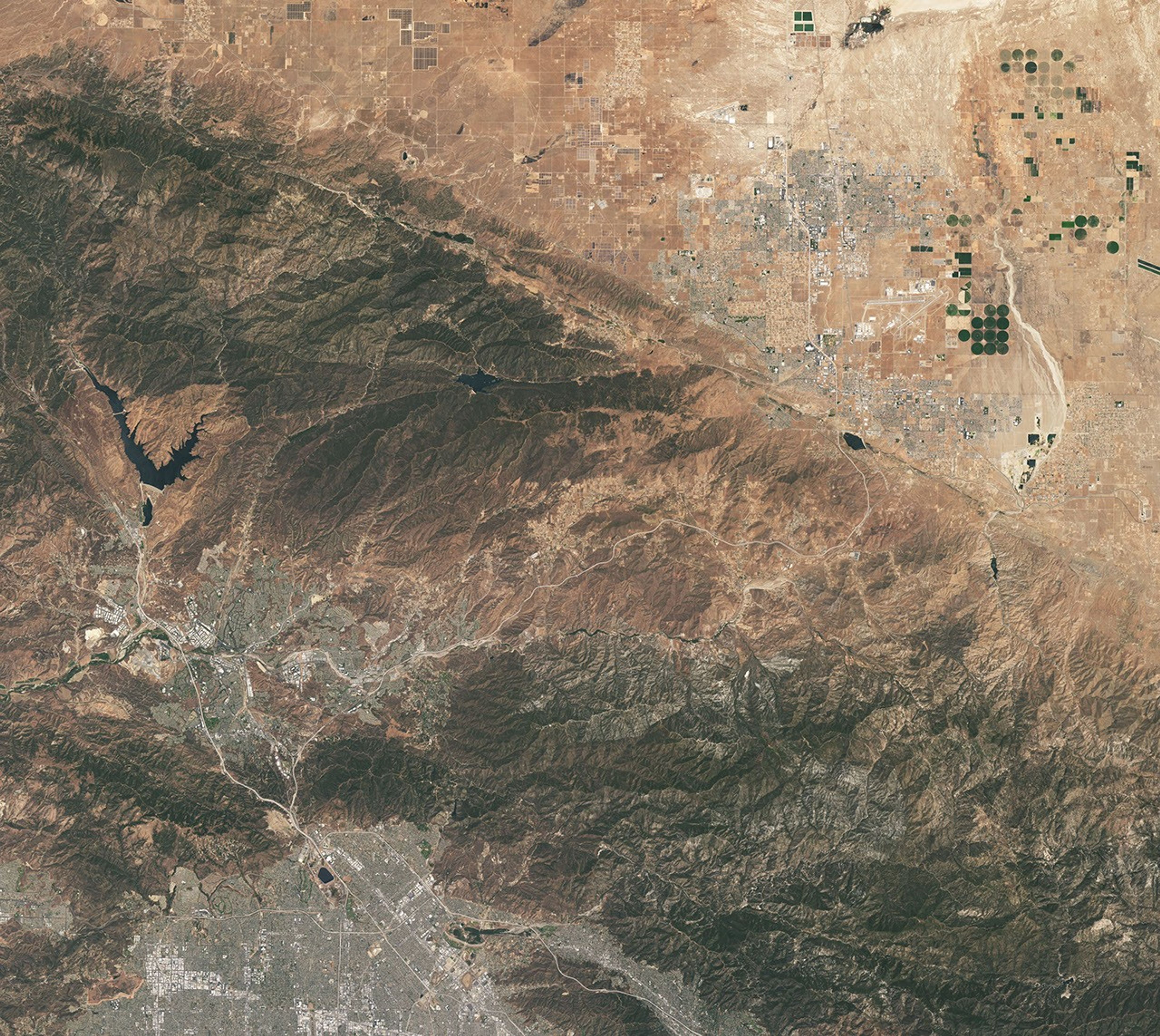
航天图片资料 · This natural-color image shows the same area, but there is less difference in colors between higher-elevation and lower-elevation vegetation. Most features in the image are shades of brown.
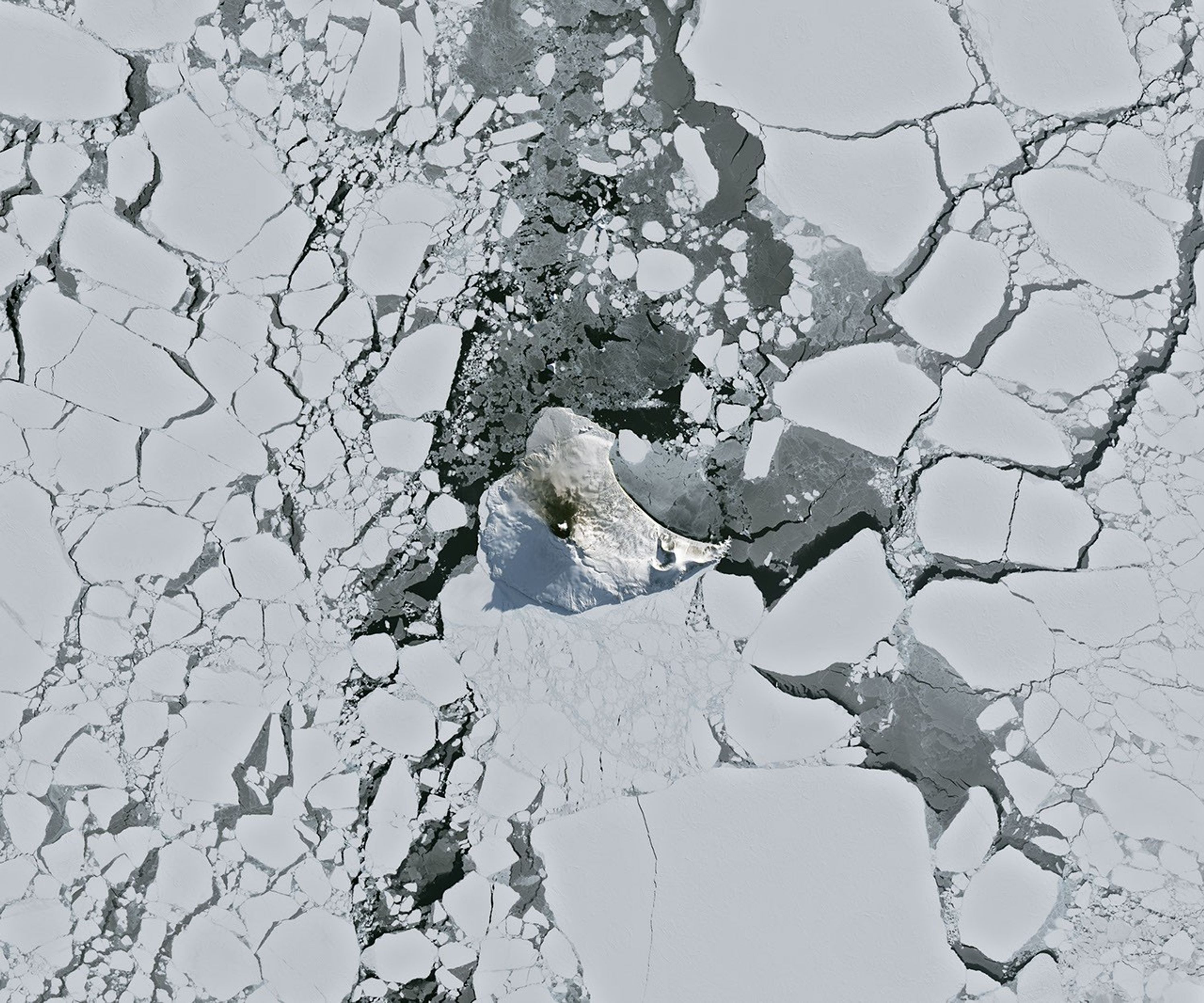
航天图片资料 · A small ice- and snow-covered island with an active volcanic crater at its center is surrounded by drifting pieces of sea ice. A thermal signal and small plume appear in the crater, and ash darkens the snow on the volcano’s northern slopes.
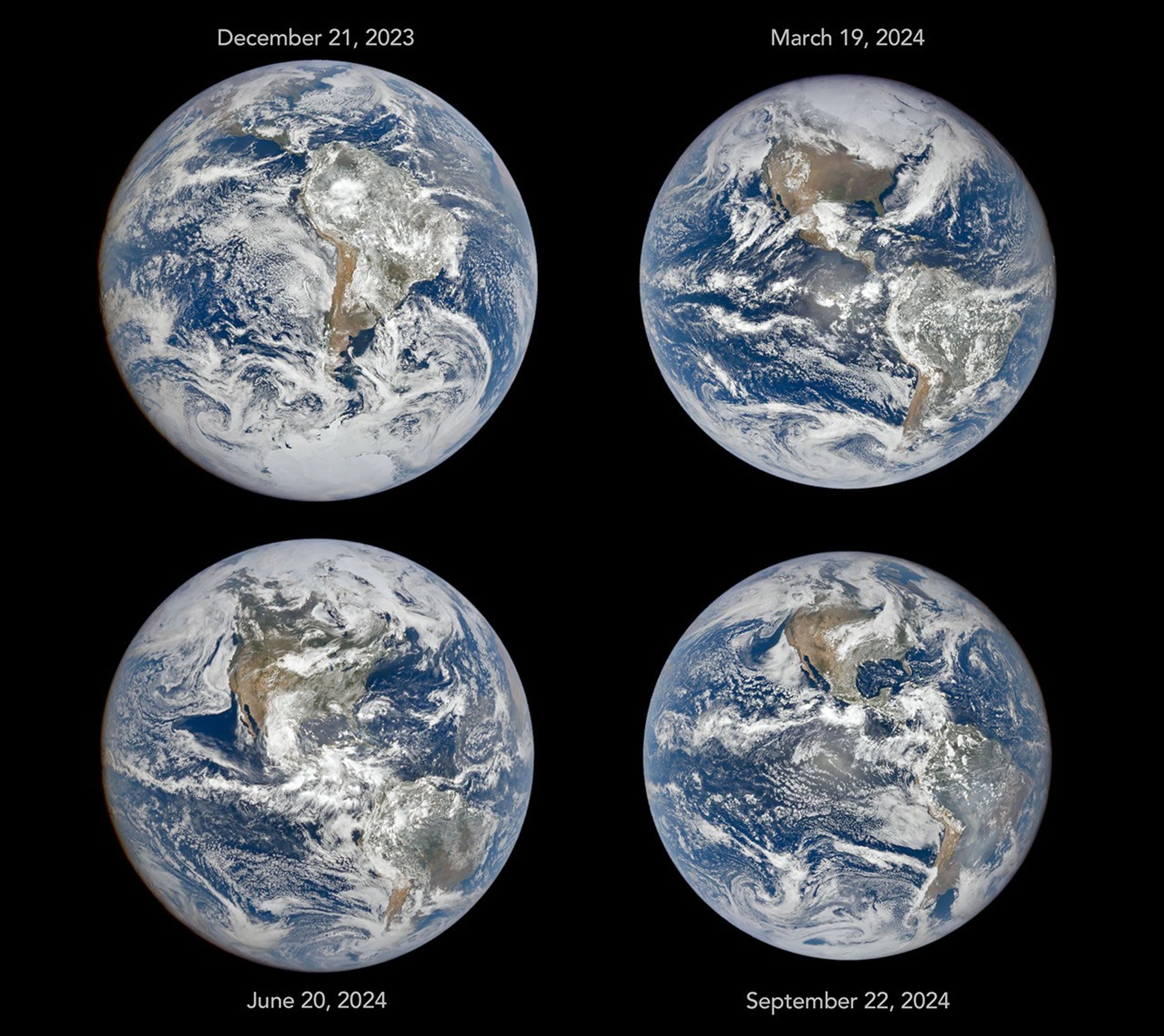
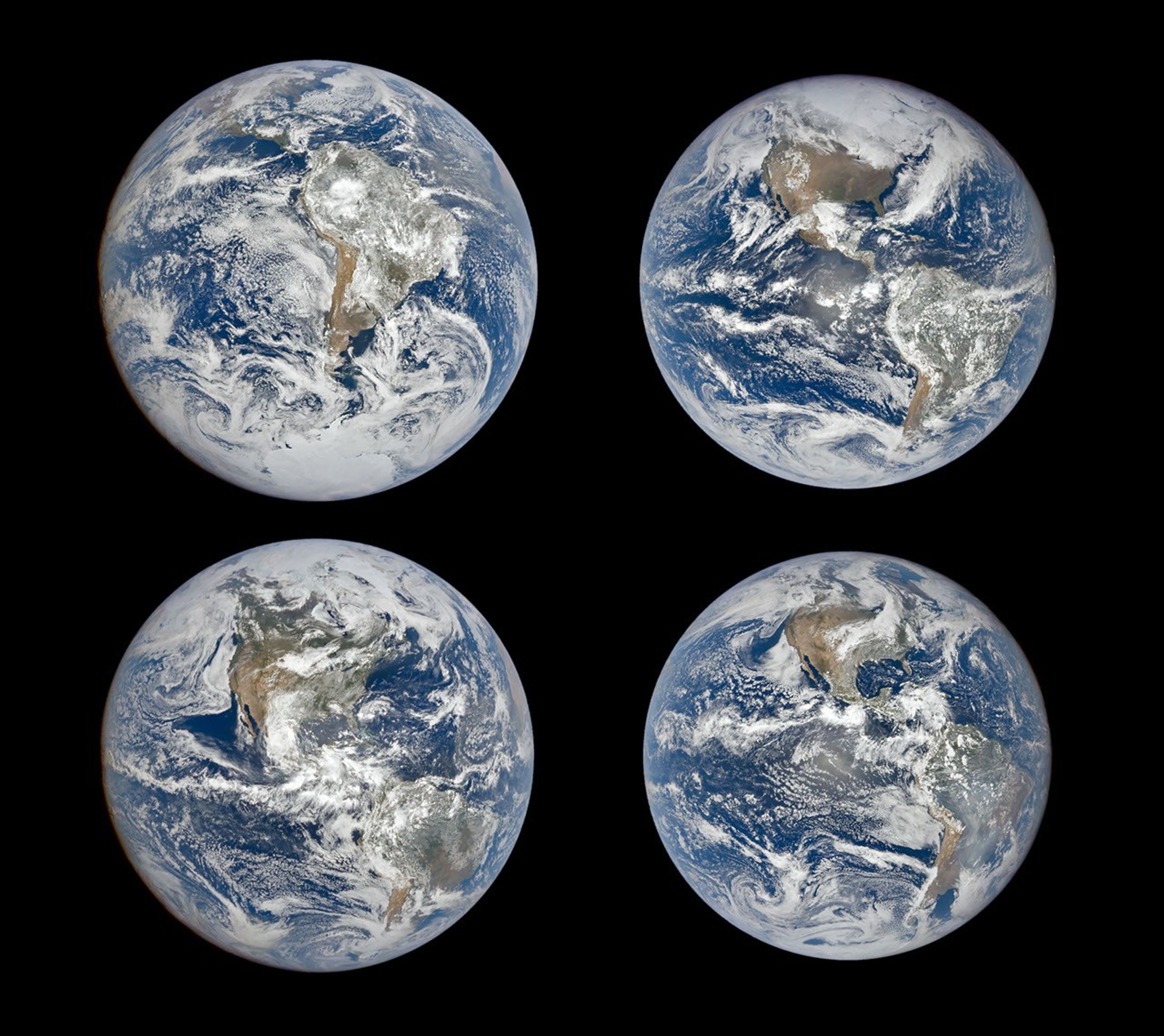
航天图片资料 · Four full-disk images of Earth are arranged in a two-by-two grid. The December image on the upper left shows the South America centered with Antarctica visible. The June image features parts of North America and Arctic sea ice that were not visible in December. The March and September images have South America and North America in more intermediate positions.
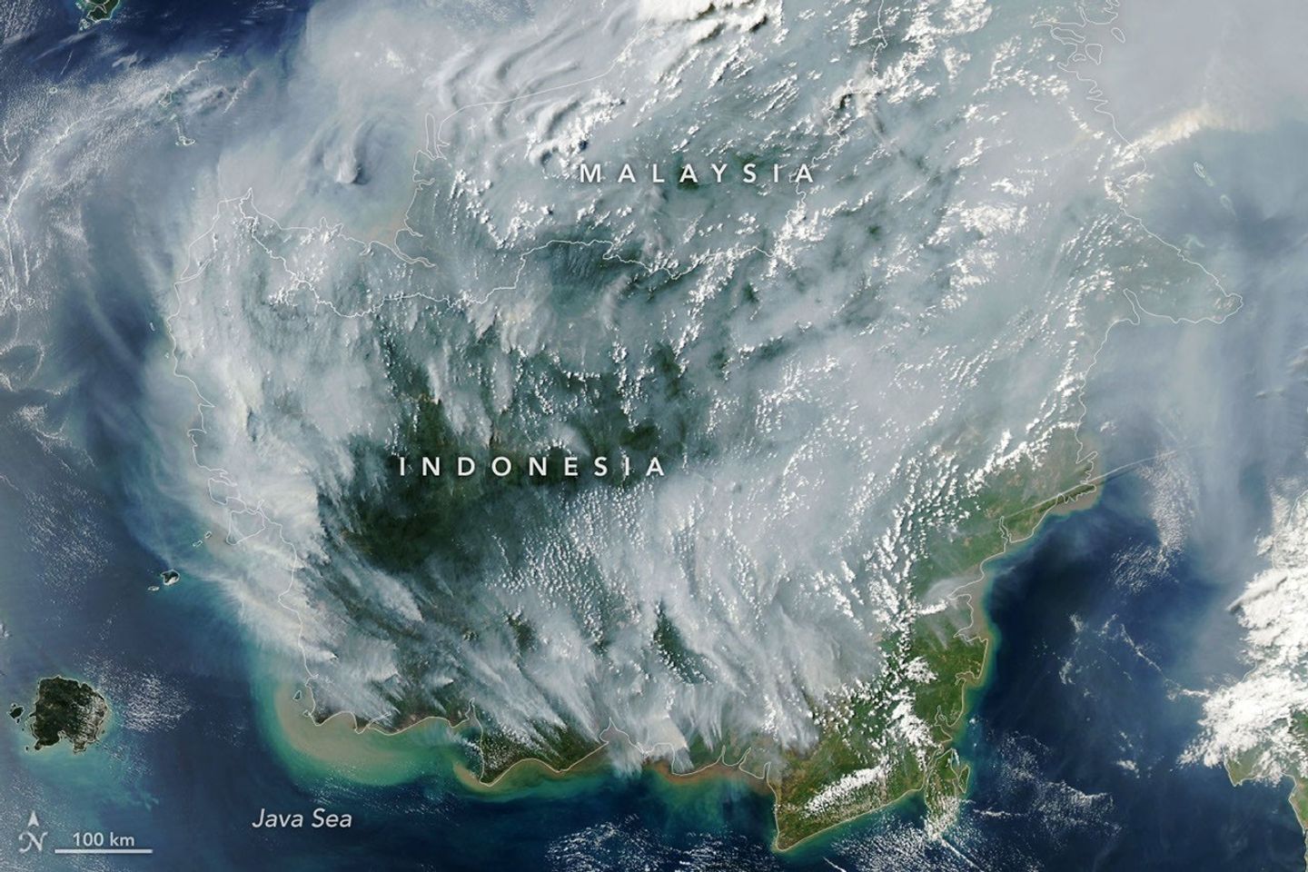
航天图片资料 · Thick gray plumes of smoke stream from large numbers of fires scattered across the island of Borneo.
航天图片资料 · A satellite image of the same Lubbock region on September 9, 2026, appears parched, with much less green vegetation and mostly dry lakes.
航天图片资料 · This natural-color image shows the same area, but there is less difference in colors between higher-elevation and lower-elevation vegetation. Most features in the image are shades of brown.
航天图片资料 · Natural-color aerial image of a wildfire in mountainous terrain. Thick gray and brown smoke spreads across much of the landscape, while a towering white pyrocumulus cloud rises at right. A smooth, thin pileus cloud hovers just below the main convective cloud.
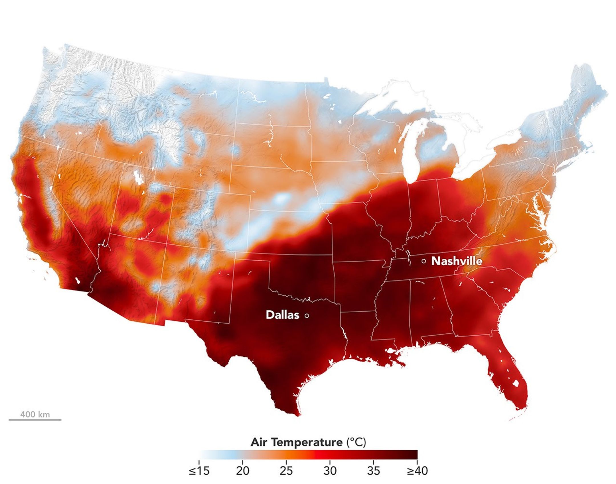
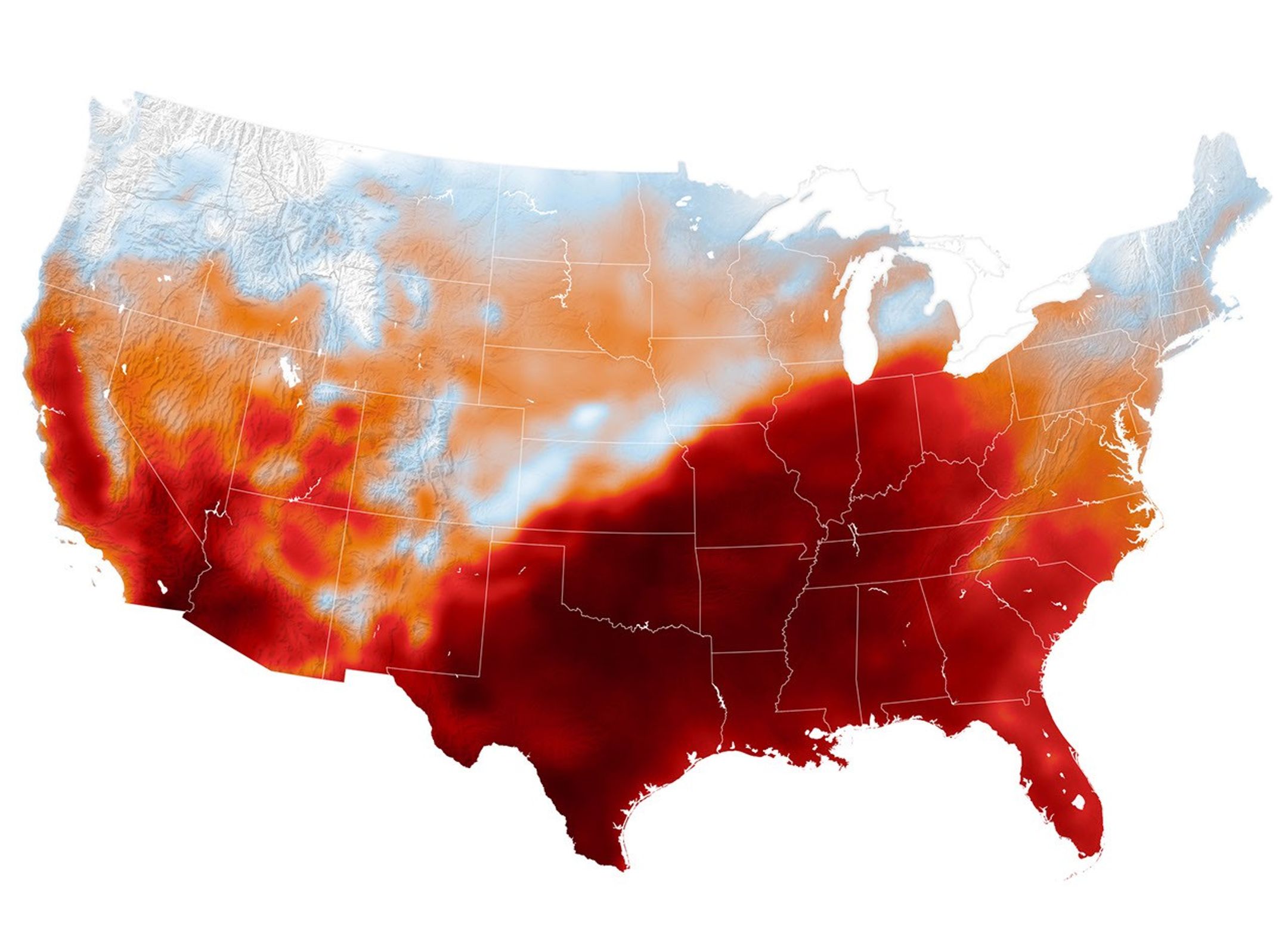
航天图片资料 · Air temperatures in the United States are depicted in white to light blue (cooler) and orange to red (warmer). An area of red, indicating temperatures around 100 degrees Fahrenheit, covers Texas and several states to the east and northeast.
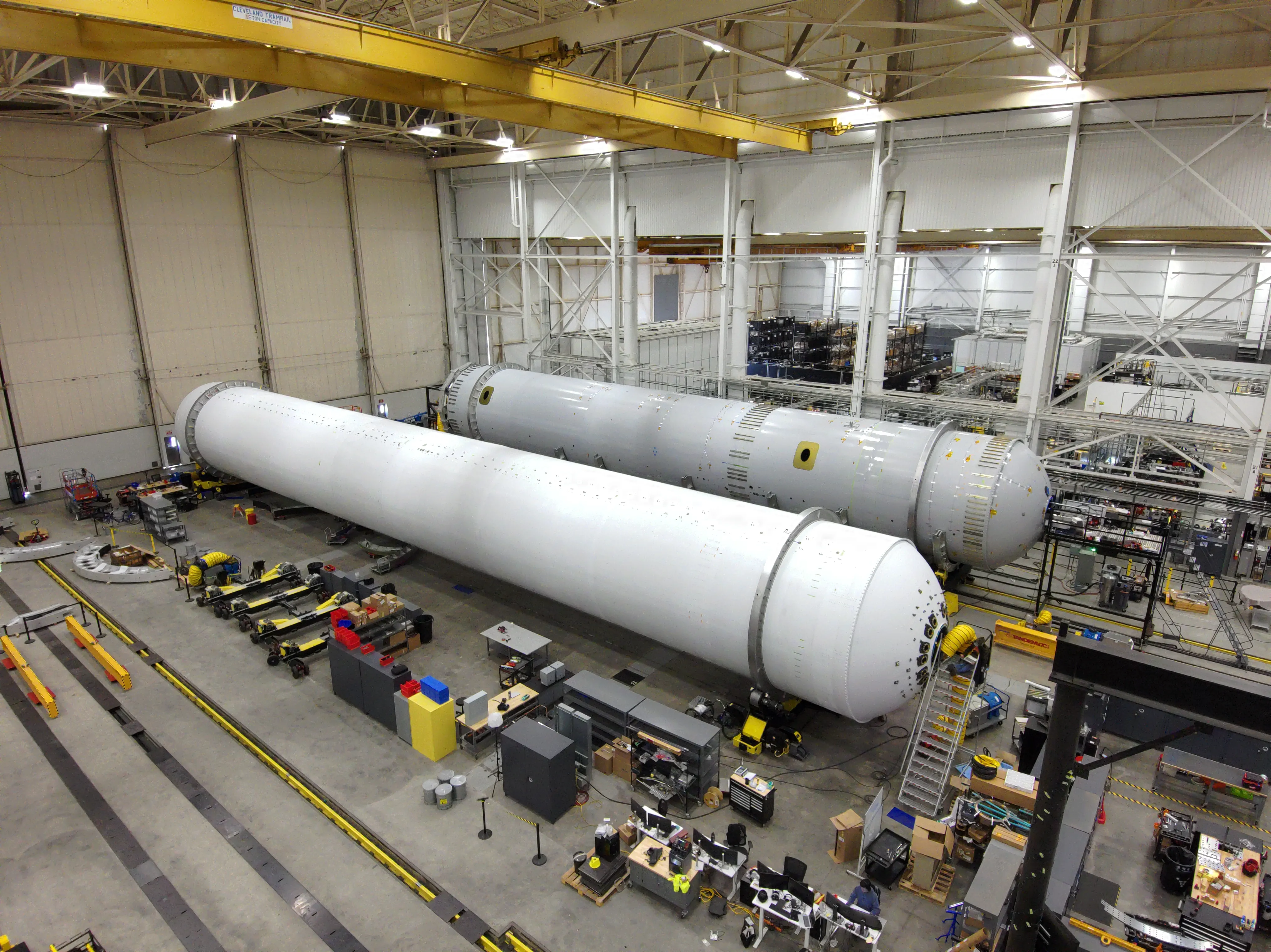
航天图片资料 · TOS-L-Relativity-Space-Jobs-03 Relativity Space's first stage flight and qualification articles for its Terran R rocket sit at the manufacturing site at its Long Beach, California facilities in this June 2026 handout image. (Courtesy/Relativity Space)
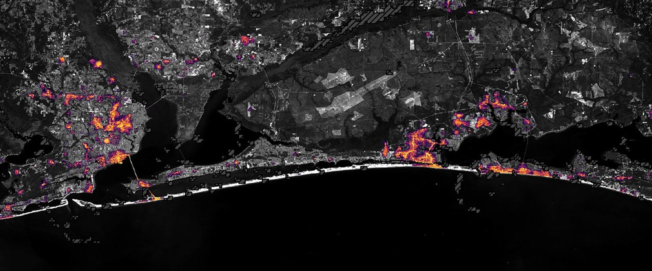
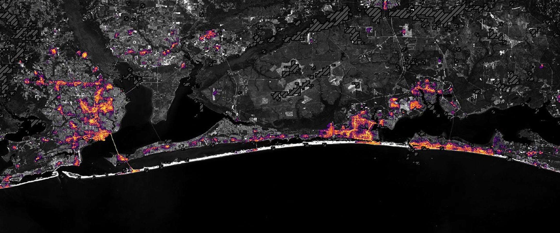
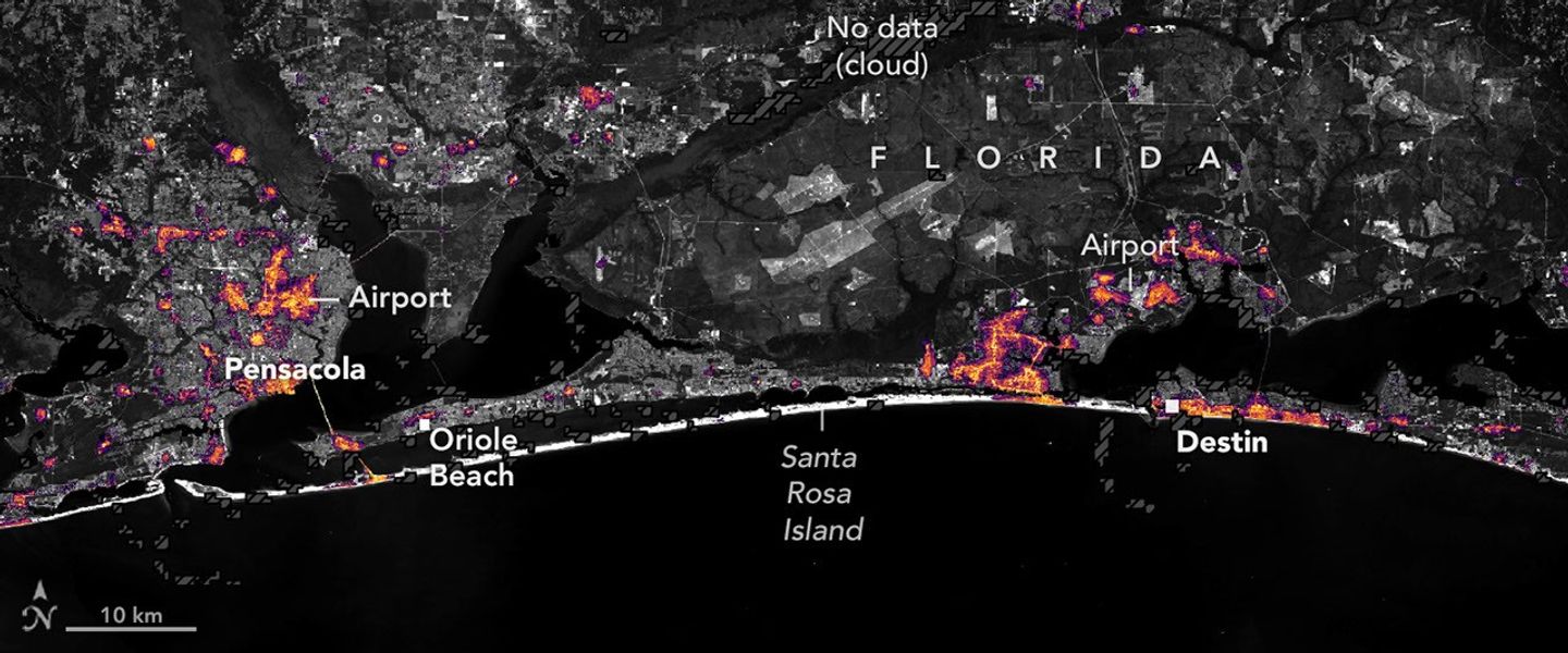
航天图片资料 · Nighttime lights along the Florida Panhandle coast on October 11, 2026, after Hurricane Isaias, with fewer and dimmer lights in Pensacola and Destin and gaps along the road between them.
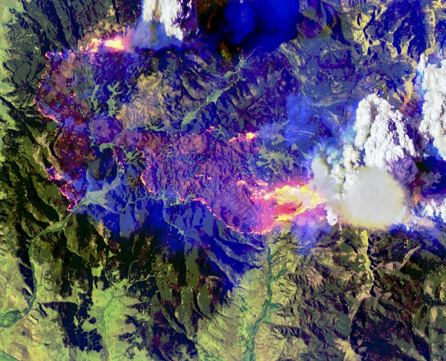
航天图片资料 · False-color aerial image of the same wildfire. Active fire fronts appear bright pink, magenta, and yellow around a large brown burned area. A towering white pyrocumulus cloud rises from the fire at right. A smooth, thin pileus cloud obscures part of its top.
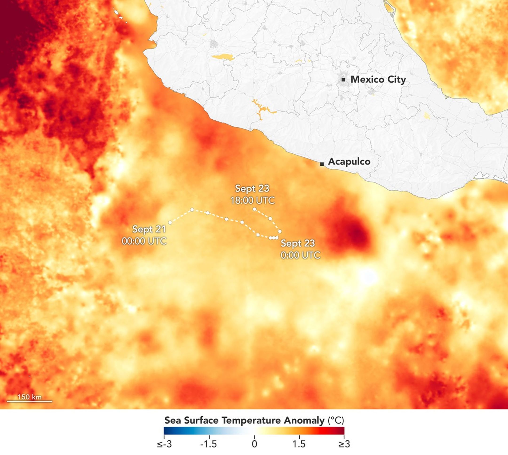
航天图片资料 · A map depicts sea surface temperature anomalies off Mexico's Pacific coast on September 23. Deep red areas highlight areas 3°C above the norm for that date. A dotted line traces the storm's path from September 20 to September 23 as it moved through the unusually warm waters.
航天图片资料 · The same area on October 12, 2026, with lights in Pensacola and Destin and along the road between them closer to pre-storm levels.
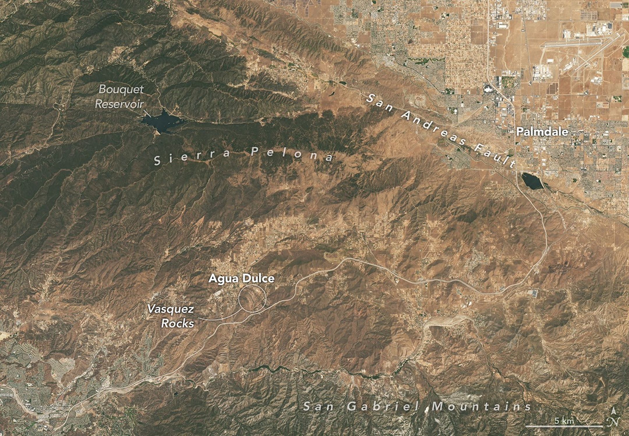
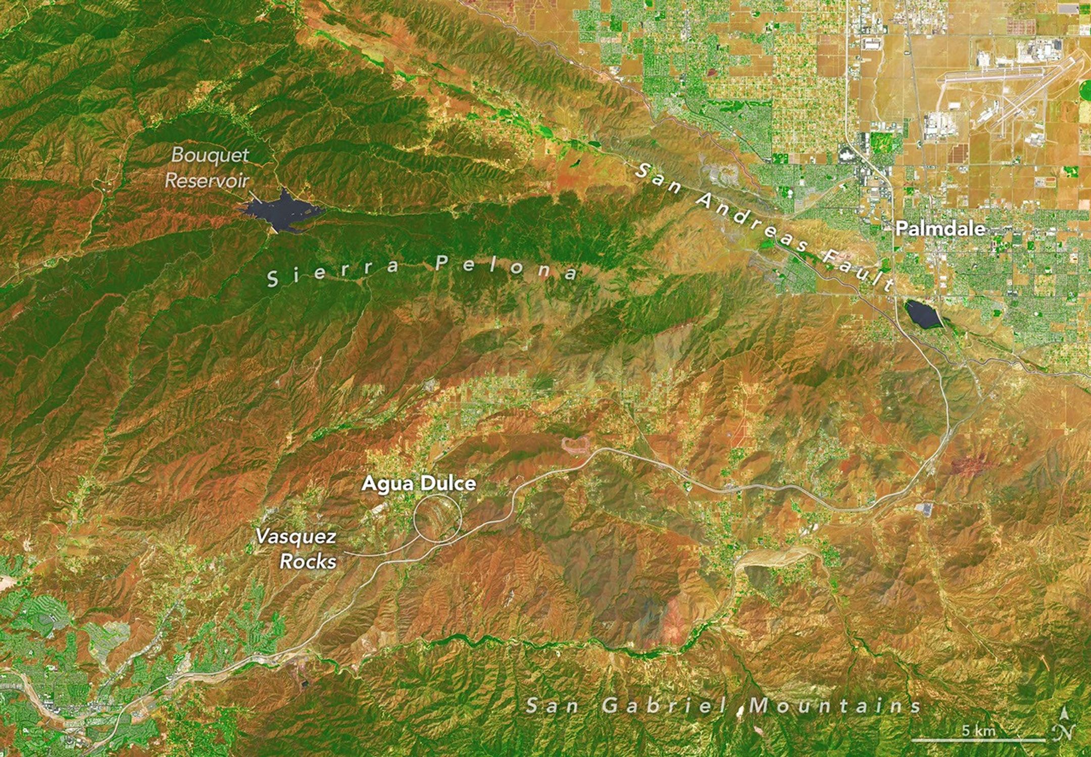
航天图片资料 · In this false-color image, areas with more extensive vegetation on the Sierra Pelona retain more moisture than the hills surrounding Agua Dulce, making the Sierra Pelona appear dark green in comparison to the rusty brown coloration of the lower hills. Vasquez Rocks appears as a patch of curved gray stripes near the center of the image.
航天图片资料 · Four full-disk images of Earth are arranged in a two-by-two grid. The December image on the upper left shows the South America centered with Antarctica visible. The June image features parts of North America and Arctic sea ice that were not visible in December. The March and September images have South America and North America in more intermediate positions.
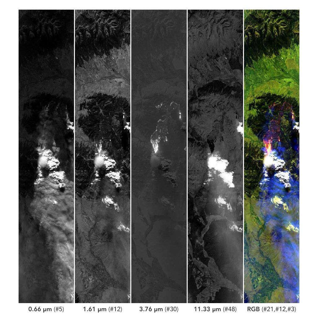
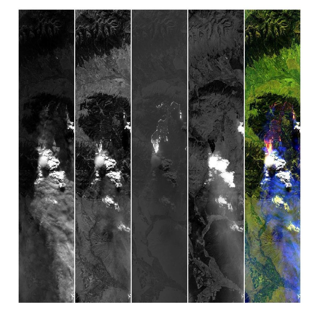
航天图片资料 · Five side-by-side panels from the MASTER instrument show a wildfire and its smoke plume. The four left panels are grayscale views of the scene at progressively longer wavelengths. The rightmost panel is a false-color composite in which active fires appear pink and yellow, burned areas in purple, smoke in purple, and clouds in white.
航天图片资料 · Air temperatures in the United States are depicted in white to light blue (cooler) and orange to red (warmer). An area of red, indicating temperatures around 100 degrees Fahrenheit, covers Texas and several states to the east and northeast.
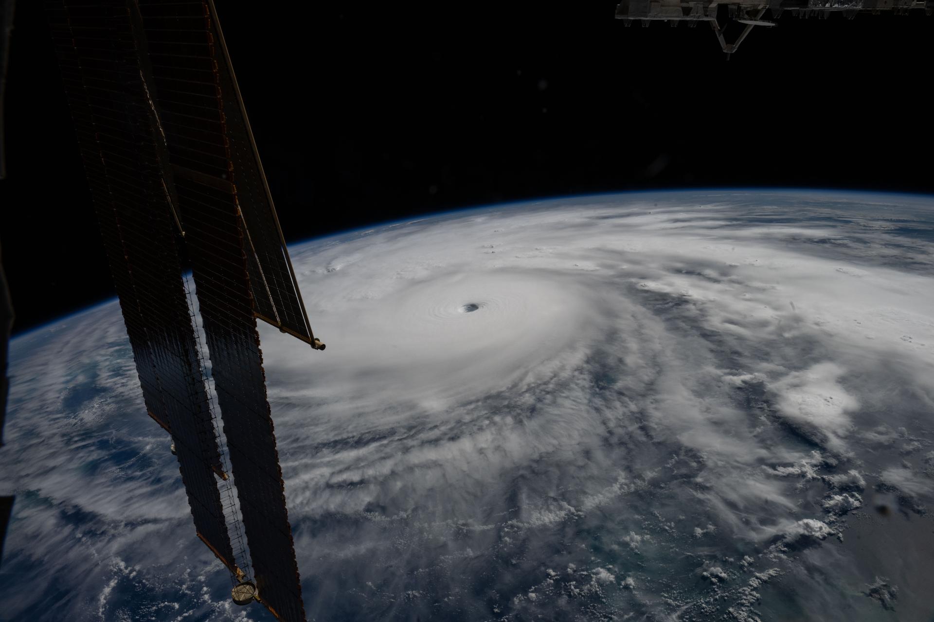
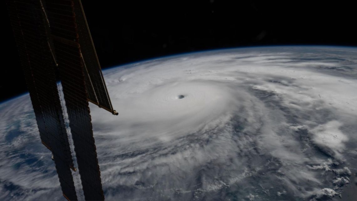
航天图片资料 · Category 5 Hurricane Melissa, one of the most powerful storms to strike the Caribbean in recent history, is pictured about 50 miles south of Jamaica in this photograph from the International Space Station as it orbited 262 miles above the Yucatan Peninsula.
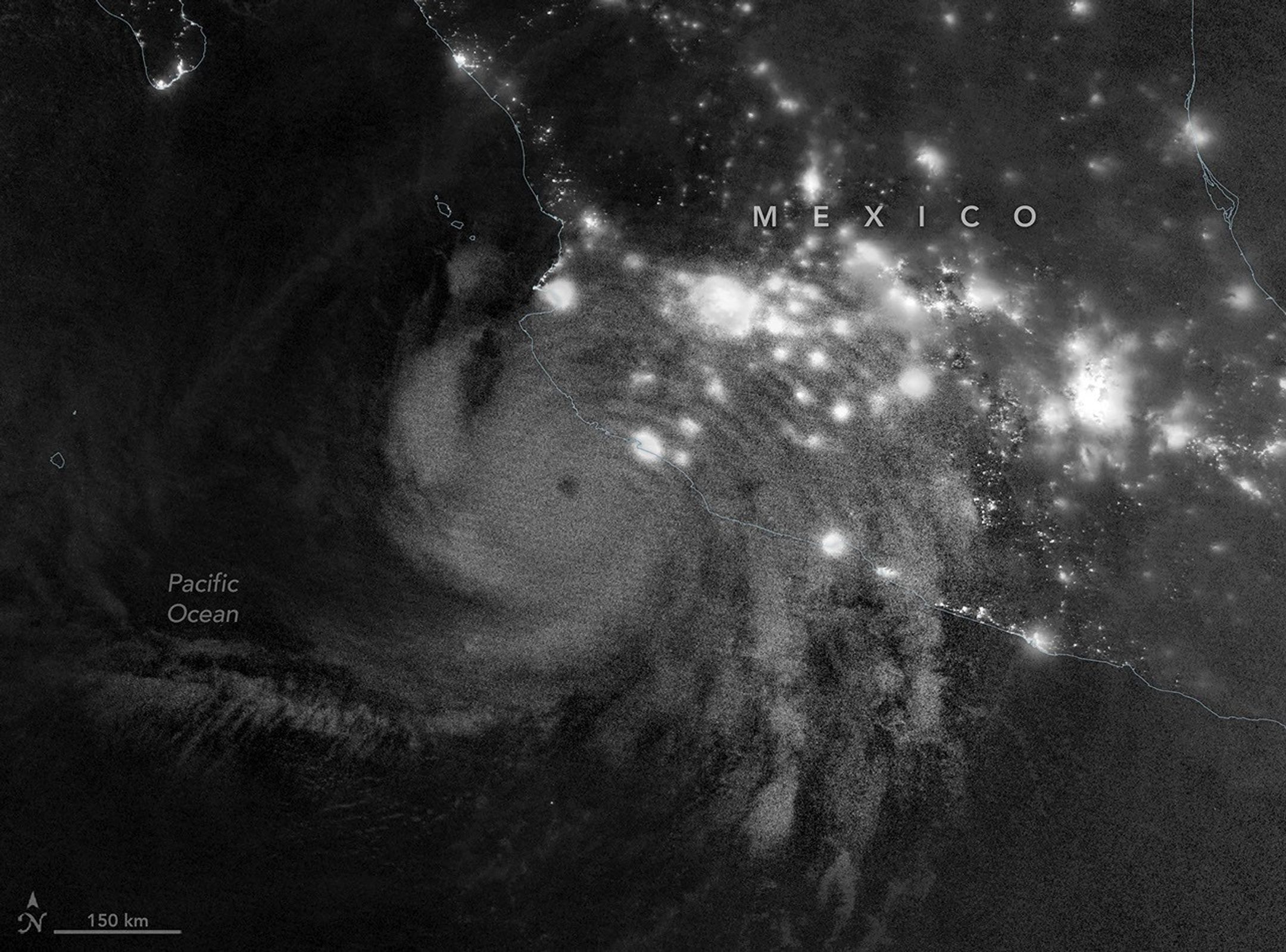
航天图片资料 · Gravity waves in the upper atmosphere appear as a semicircle of ripples in a nighttime, grayscale satellite image. Hurricane clouds and city lights in Mexico are also visible.
航天图片资料 · Five side-by-side panels from the MASTER instrument show a wildfire and its smoke plume. The four left panels are grayscale views of the scene at progressively longer wavelengths. The rightmost panel is a false-color composite in which active fires appear pink and yellow, burned areas in purple, smoke in purple, and clouds in white.
航天图片资料 · e5a5c578b5c116b9
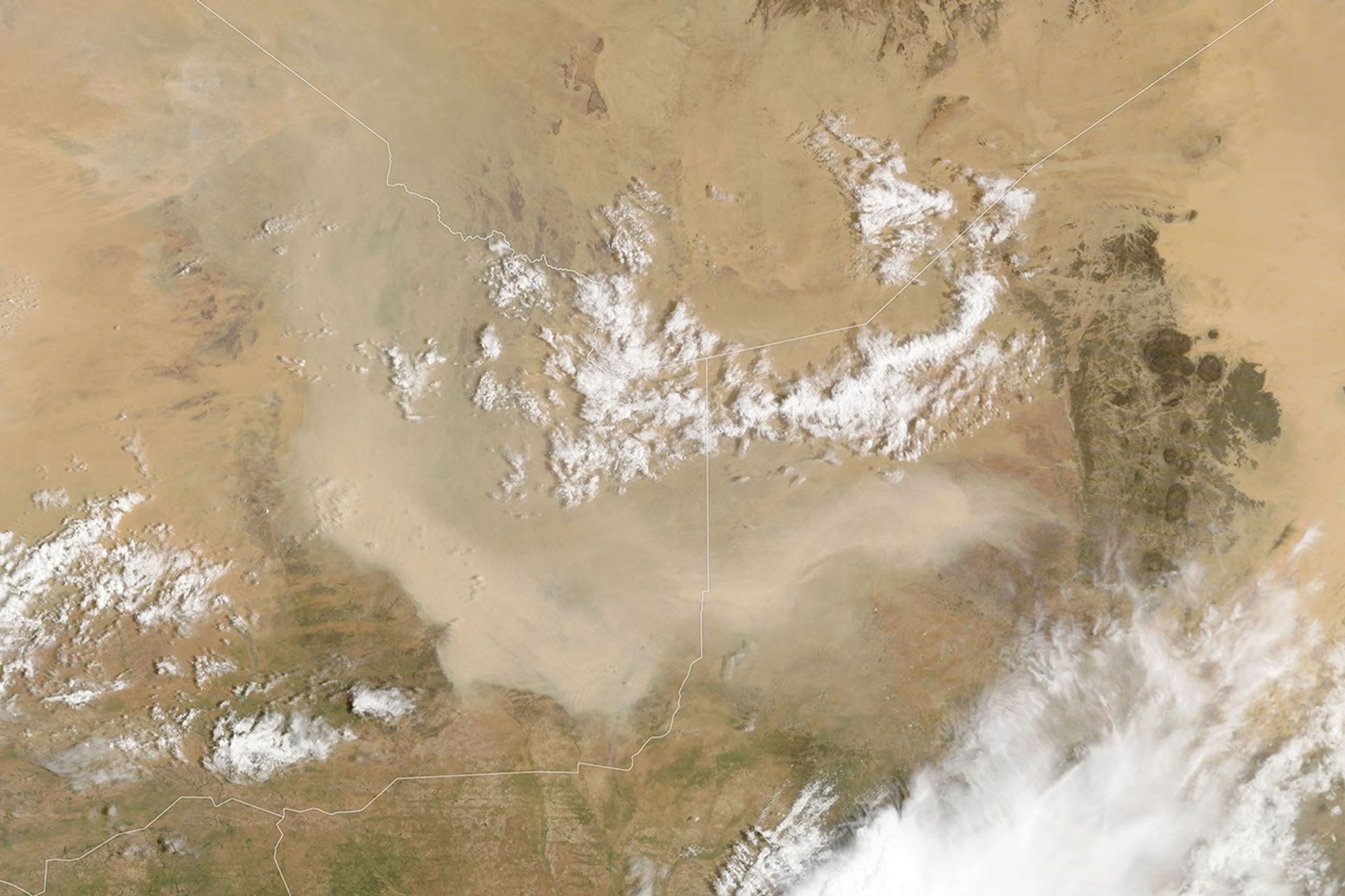
航天图片资料 · A light brown dust plume, dense at its center and more diffuse toward its edges, extends horizontally across an orange-brown and green landscape. Scattered white clouds cover some of the scene.
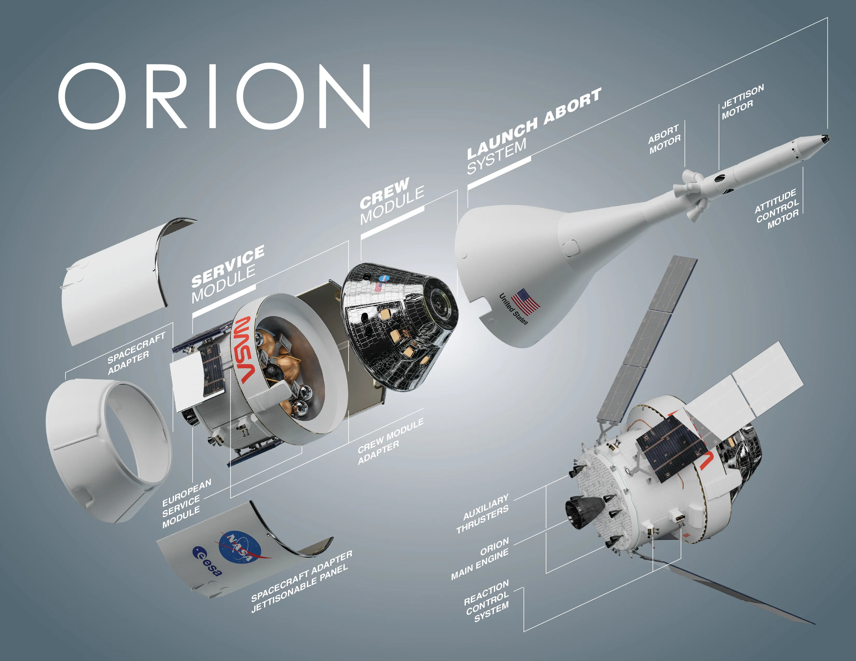
航天图片资料 · Exploded diagram of NASA's Orion spacecraft showing labeled parts: spacecraft adapter, service module, crew module, and launch abort system, with various components highlighted against a gray background.
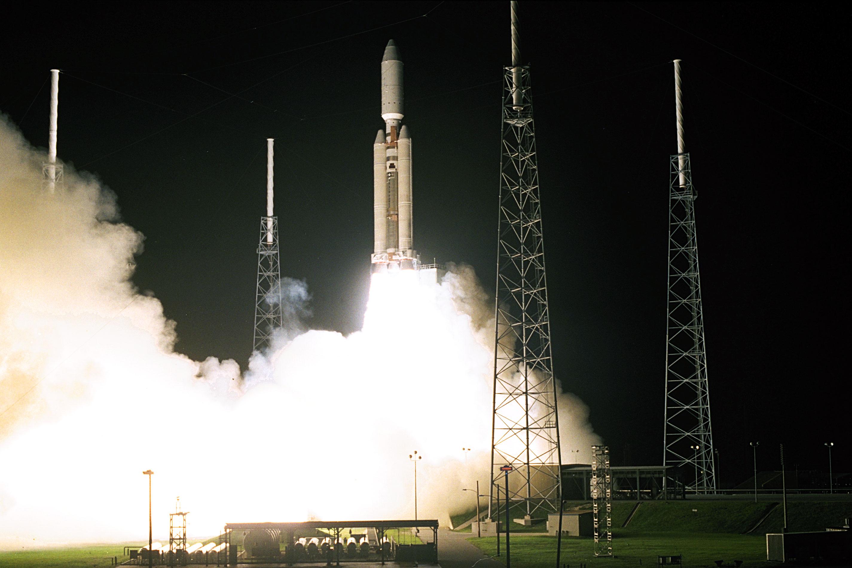
航天图片资料 · NASA's Cassini spacecraft lifts off on Oct. 15, 1997, atop a Titan IVB rocket.
航天图片资料 · Nighttime lights along the Florida Panhandle coast on October 11, 2026, after Hurricane Isaias, with fewer and dimmer lights in Pensacola and Destin and gaps along the road between them.
航天图片资料 · NASA insignia.
航天图片资料 · NASA meatball
航天图片资料 · In a full-disk satellite view of Earth, several tropical cyclones swirl above the blue waters of the Pacific Ocean.
航天图片资料 · A satellite image of farmland around Lubbock, Texas, on September 22, 2025, features a patchwork of green and brown agricultural fields and several playa lakes with varying amounts of water.
航天图片资料 · A satellite image of farmland around Lubbock, Texas, on September 22, 2025, features a patchwork of green and brown agricultural fields and several playa lakes with varying amounts of water. · 来源署名:NASA · 原始许可标注:NASA Image and Media Guidelines
航天图片资料 · A river winds through a mostly green tundra landscape in summer, dotted with numerous lakes.
航天图片资料 · A river winds through a mostly green tundra landscape in summer, dotted with numerous lakes. · 来源署名:NASA · 原始许可标注:NASA Image and Media Guidelines
航天图片资料 · In a full-disk satellite view of Earth, several tropical cyclones swirl above the blue waters of the Pacific Ocean.
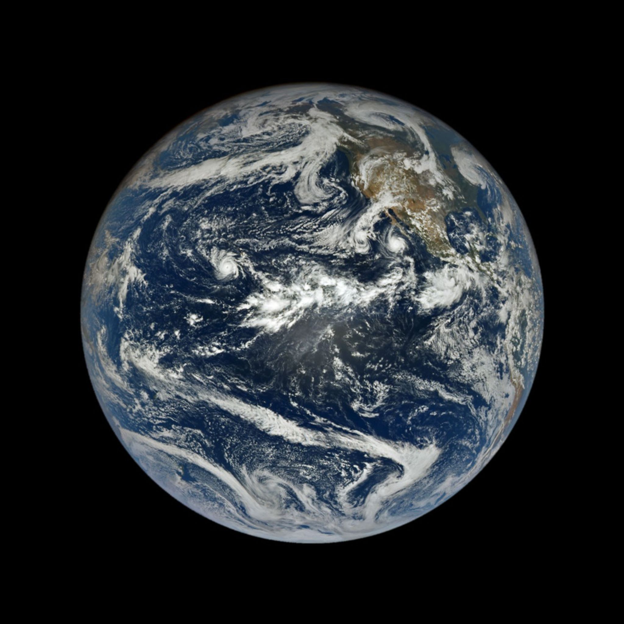
航天图片资料 · In a full-disk satellite view of Earth, several tropical cyclones swirl above the blue waters of the Pacific Ocean. · 来源署名:NASA · 原始许可标注:NASA Image and Media Guidelines
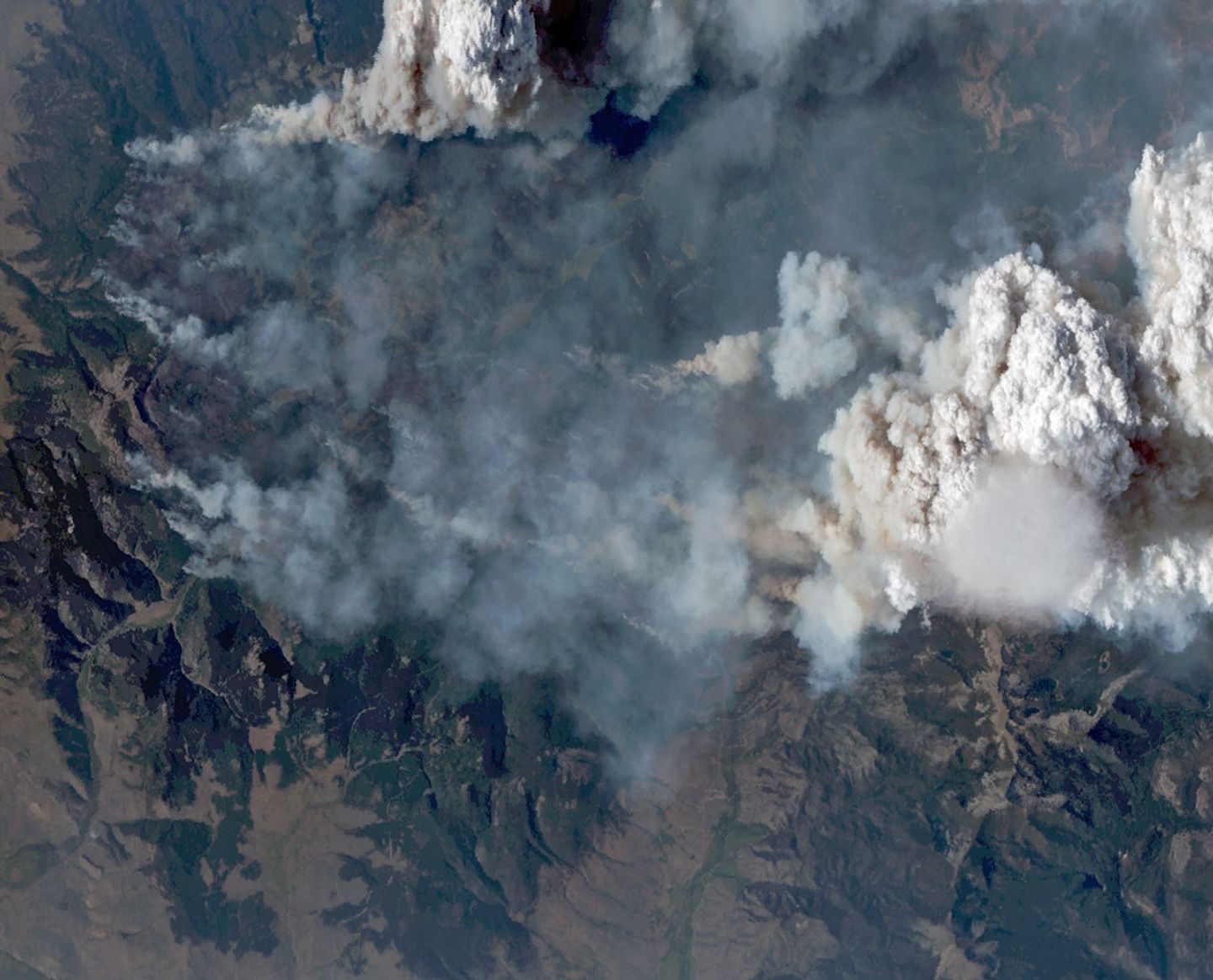
航天图片资料 · Natural-color aerial image of a wildfire in mountainous terrain. Thick gray and brown smoke spreads across much of the landscape, while a towering white pyrocumulus cloud rises at right. A smooth, thin pileus cloud hovers just below the main convective cloud.
航天图片资料 · Natural-color aerial image of a wildfire in mountainous terrain. Thick gray and brown smoke spreads across much of the landscape, while a towering white pyrocumulus cloud rises at right. A smooth, thin pileus cloud hovers just below the main convective cloud. · 来源署名:NASA · 原始许可标注:NASA Image and Media Guidelines
航天图片资料 · People in clean suits work on a spacecraft in a large chamber.
航天图片资料 · People in clean suits work on a spacecraft in a large chamber. · 来源署名:NASA · 原始许可标注:NASA Image and Media Guidelines
航天图片资料 · map showing the possible visibility of the northern lights over the US. in the background are vivid green and magenta auroras.
航天图片资料 · map showing the possible visibility of the northern lights over the US. in the background are vivid green and magenta auroras. · 来源署名:Space.com · 原始许可标注:许可未标注,不构成转载授权
航天图片资料 · A river winds through the same tundra landscape in autumn, now colored red and orange. Some green vegetation remains visible along the river.
航天图片资料 · A river winds through the same tundra landscape in autumn, now colored red and orange. Some green vegetation remains visible along the river. · 来源署名:NASA · 原始许可标注:NASA Image and Media Guidelines
航天图片资料 · Smoke covers much of the southern third of New Guinea, while clouds and east-west-running mountain ranges are visible in the northern part of the island.
航天图片资料 · Smoke covers much of the southern third of New Guinea, while clouds and east-west-running mountain ranges are visible in the northern part of the island. · 来源署名:NASA · 原始许可标注:NASA Image and Media Guidelines
航天图片资料 · A series of V-shaped wave clouds appears over an ocean filled with pieces of sea ice.
航天图片资料 · A series of V-shaped wave clouds appears over an ocean filled with pieces of sea ice. · 来源署名:NASA · 原始许可标注:NASA Image and Media Guidelines
航天图片资料 · NASA Adds Relativity Space's Terran R to Launch Services Contract NASA ©
航天图片资料 · NASA Adds Relativity Space's Terran R to Launch Services Contract NASA © · 来源署名:asdnews.com · 原始许可标注:许可未标注,不构成转载授权
航天图片资料 · This natural-color image shows the same area, but there is less difference in colors between higher-elevation and lower-elevation vegetation. Most features in the image are shades of brown.
航天图片资料 · This natural-color image shows the same area, but there is less difference in colors between higher-elevation and lower-elevation vegetation. Most features in the image are shades of brown. · 来源署名:NASA · 原始许可标注:NASA Image and Media Guidelines
航天图片资料 · A small ice- and snow-covered island with an active volcanic crater at its center is surrounded by drifting pieces of sea ice. A thermal signal and small plume appear in the crater, and ash darkens the snow on the volcano’s northern slopes.
航天图片资料 · A small ice- and snow-covered island with an active volcanic crater at its center is surrounded by drifting pieces of sea ice. A thermal signal and small plume appear in the crater, and ash darkens the snow on the volcano’s northern slopes. · 来源署名:NASA · 原始许可标注:NASA Image and Media Guidelines
航天图片资料 · Four full-disk images of Earth are arranged in a two-by-two grid. The December image on the upper left shows the South America centered with Antarctica visible. The June image features parts of North America and Arctic sea ice that were not visible in December. The March and September images have South America and North America in more intermediate positions.
航天图片资料 · Four full-disk images of Earth are arranged in a two-by-two grid. The December image on the upper left shows the South America centered with Antarctica visible. The June image features parts of North America and Arctic sea ice that were not visible in December. The March and September images have South America and North America in more intermediate positions. · 来源署名:NASA · 原始许可标注:NASA Image and Media Guidelines
航天图片资料 · Thick gray plumes of smoke stream from large numbers of fires scattered across the island of Borneo.
航天图片资料 · Thick gray plumes of smoke stream from large numbers of fires scattered across the island of Borneo. · 来源署名:NASA · 原始许可标注:NASA Image and Media Guidelines
航天图片资料 · A satellite image of the same Lubbock region on September 9, 2026, appears parched, with much less green vegetation and mostly dry lakes.
航天图片资料 · A satellite image of the same Lubbock region on September 9, 2026, appears parched, with much less green vegetation and mostly dry lakes. · 来源署名:NASA · 原始许可标注:NASA Image and Media Guidelines
航天图片资料 · This natural-color image shows the same area, but there is less difference in colors between higher-elevation and lower-elevation vegetation. Most features in the image are shades of brown.
航天图片资料 · This natural-color image shows the same area, but there is less difference in colors between higher-elevation and lower-elevation vegetation. Most features in the image are shades of brown. · 来源署名:NASA · 原始许可标注:NASA Image and Media Guidelines
航天图片资料 · Natural-color aerial image of a wildfire in mountainous terrain. Thick gray and brown smoke spreads across much of the landscape, while a towering white pyrocumulus cloud rises at right. A smooth, thin pileus cloud hovers just below the main convective cloud.
航天图片资料 · Natural-color aerial image of a wildfire in mountainous terrain. Thick gray and brown smoke spreads across much of the landscape, while a towering white pyrocumulus cloud rises at right. A smooth, thin pileus cloud hovers just below the main convective cloud. · 来源署名:NASA · 原始许可标注:NASA Image and Media Guidelines
航天图片资料 · Air temperatures in the United States are depicted in white to light blue (cooler) and orange to red (warmer). An area of red, indicating temperatures around 100 degrees Fahrenheit, covers Texas and several states to the east and northeast.
航天图片资料 · Air temperatures in the United States are depicted in white to light blue (cooler) and orange to red (warmer). An area of red, indicating temperatures around 100 degrees Fahrenheit, covers Texas and several states to the east and northeast. · 来源署名:NASA · 原始许可标注:NASA Image and Media Guidelines
航天图片资料 · TOS-L-Relativity-Space-Jobs-03 Relativity Space's first stage flight and qualification articles for its Terran R rocket sit at the manufacturing site at its Long Beach, California facilities in this June 2026 handout image. (Courtesy/Relativity Space)
航天图片资料 · TOS-L-Relativity-Space-Jobs-03 Relativity Space's first stage flight and qualification articles for its Terran R rocket sit at the manufacturing site at its Long Beach, California facilities in this June 2026 handout image. (Courtesy/Relativity Space) · 来源署名:orlandosentinel.com · 原始许可标注:许可未标注,不构成转载授权
航天图片资料 · Nighttime lights along the Florida Panhandle coast on October 11, 2026, after Hurricane Isaias, with fewer and dimmer lights in Pensacola and Destin and gaps along the road between them.
航天图片资料 · Nighttime lights along the Florida Panhandle coast on October 11, 2026, after Hurricane Isaias, with fewer and dimmer lights in Pensacola and Destin and gaps along the road between them. · 来源署名:NASA · 原始许可标注:NASA Image and Media Guidelines
航天图片资料 · False-color aerial image of the same wildfire. Active fire fronts appear bright pink, magenta, and yellow around a large brown burned area. A towering white pyrocumulus cloud rises from the fire at right. A smooth, thin pileus cloud obscures part of its top.
航天图片资料 · False-color aerial image of the same wildfire. Active fire fronts appear bright pink, magenta, and yellow around a large brown burned area. A towering white pyrocumulus cloud rises from the fire at right. A smooth, thin pileus cloud obscures part of its top. · 来源署名:NASA · 原始许可标注:NASA Image and Media Guidelines
航天图片资料 · A map depicts sea surface temperature anomalies off Mexico's Pacific coast on September 23. Deep red areas highlight areas 3°C above the norm for that date. A dotted line traces the storm's path from September 20 to September 23 as it moved through the unusually warm waters.
航天图片资料 · A map depicts sea surface temperature anomalies off Mexico's Pacific coast on September 23. Deep red areas highlight areas 3°C above the norm for that date. A dotted line traces the storm's path from September 20 to September 23 as it moved through the unusually warm waters. · 来源署名:NASA · 原始许可标注:NASA Image and Media Guidelines
航天图片资料 · The same area on October 12, 2026, with lights in Pensacola and Destin and along the road between them closer to pre-storm levels.
航天图片资料 · The same area on October 12, 2026, with lights in Pensacola and Destin and along the road between them closer to pre-storm levels. · 来源署名:NASA · 原始许可标注:NASA Image and Media Guidelines
航天图片资料 · In this false-color image, areas with more extensive vegetation on the Sierra Pelona retain more moisture than the hills surrounding Agua Dulce, making the Sierra Pelona appear dark green in comparison to the rusty brown coloration of the lower hills. Vasquez Rocks appears as a patch of curved gray stripes near the center of the image.
航天图片资料 · In this false-color image, areas with more extensive vegetation on the Sierra Pelona retain more moisture than the hills surrounding Agua Dulce, making the Sierra Pelona appear dark green in comparison to the rusty brown coloration of the lower hills. Vasquez Rocks appears as a patch of curved gray stripes near the center of the image. · 来源署名:NASA · 原始许可标注:NASA Image and Media Guidelines
航天图片资料 · Four full-disk images of Earth are arranged in a two-by-two grid. The December image on the upper left shows the South America centered with Antarctica visible. The June image features parts of North America and Arctic sea ice that were not visible in December. The March and September images have South America and North America in more intermediate positions.
航天图片资料 · Four full-disk images of Earth are arranged in a two-by-two grid. The December image on the upper left shows the South America centered with Antarctica visible. The June image features parts of North America and Arctic sea ice that were not visible in December. The March and September images have South America and North America in more intermediate positions. · 来源署名:NASA · 原始许可标注:NASA Image and Media Guidelines
航天图片资料 · Five side-by-side panels from the MASTER instrument show a wildfire and its smoke plume. The four left panels are grayscale views of the scene at progressively longer wavelengths. The rightmost panel is a false-color composite in which active fires appear pink and yellow, burned areas in purple, smoke in purple, and clouds in white.
航天图片资料 · Five side-by-side panels from the MASTER instrument show a wildfire and its smoke plume. The four left panels are grayscale views of the scene at progressively longer wavelengths. The rightmost panel is a false-color composite in which active fires appear pink and yellow, burned areas in purple, smoke in purple, and clouds in white. · 来源署名:NASA · 原始许可标注:NASA Image and Media Guidelines
航天图片资料 · Air temperatures in the United States are depicted in white to light blue (cooler) and orange to red (warmer). An area of red, indicating temperatures around 100 degrees Fahrenheit, covers Texas and several states to the east and northeast.
航天图片资料 · Air temperatures in the United States are depicted in white to light blue (cooler) and orange to red (warmer). An area of red, indicating temperatures around 100 degrees Fahrenheit, covers Texas and several states to the east and northeast. · 来源署名:NASA · 原始许可标注:NASA Image and Media Guidelines
航天图片资料 · Category 5 Hurricane Melissa, one of the most powerful storms to strike the Caribbean in recent history, is pictured about 50 miles south of Jamaica in this photograph from the International Space Station as it orbited 262 miles above the Yucatan Peninsula.
航天图片资料 · Category 5 Hurricane Melissa, one of the most powerful storms to strike the Caribbean in recent history, is pictured about 50 miles south of Jamaica in this photograph from the International Space Station as it orbited 262 miles above the Yucatan Peninsula. · 来源署名:NASA · 原始许可标注:NASA Image and Media Guidelines
航天图片资料 · Gravity waves in the upper atmosphere appear as a semicircle of ripples in a nighttime, grayscale satellite image. Hurricane clouds and city lights in Mexico are also visible.
航天图片资料 · Gravity waves in the upper atmosphere appear as a semicircle of ripples in a nighttime, grayscale satellite image. Hurricane clouds and city lights in Mexico are also visible. · 来源署名:NASA · 原始许可标注:NASA Image and Media Guidelines
航天图片资料 · Five side-by-side panels from the MASTER instrument show a wildfire and its smoke plume. The four left panels are grayscale views of the scene at progressively longer wavelengths. The rightmost panel is a false-color composite in which active fires appear pink and yellow, burned areas in purple, smoke in purple, and clouds in white.
航天图片资料 · Five side-by-side panels from the MASTER instrument show a wildfire and its smoke plume. The four left panels are grayscale views of the scene at progressively longer wavelengths. The rightmost panel is a false-color composite in which active fires appear pink and yellow, burned areas in purple, smoke in purple, and clouds in white. · 来源署名:NASA · 原始许可标注:NASA Image and Media Guidelines
航天图片资料 · e5a5c578b5c116b9
航天图片资料 · e5a5c578b5c116b9 · 来源署名:noticiasambientales.com · 原始许可标注:许可未标注,不构成转载授权
航天图片资料 · A light brown dust plume, dense at its center and more diffuse toward its edges, extends horizontally across an orange-brown and green landscape. Scattered white clouds cover some of the scene.
航天图片资料 · A light brown dust plume, dense at its center and more diffuse toward its edges, extends horizontally across an orange-brown and green landscape. Scattered white clouds cover some of the scene. · 来源署名:NASA · 原始许可标注:NASA Image and Media Guidelines
航天图片资料 · Exploded diagram of NASA's Orion spacecraft showing labeled parts: spacecraft adapter, service module, crew module, and launch abort system, with various components highlighted against a gray background.
航天图片资料 · Exploded diagram of NASA's Orion spacecraft showing labeled parts: spacecraft adapter, service module, crew module, and launch abort system, with various components highlighted against a gray background. · 来源署名:NASA · 原始许可标注:NASA Image and Media Guidelines
航天图片资料 · NASA's Cassini spacecraft lifts off on Oct. 15, 1997, atop a Titan IVB rocket.
航天图片资料 · NASA's Cassini spacecraft lifts off on Oct. 15, 1997, atop a Titan IVB rocket. · 来源署名:Space.com · 原始许可标注:许可未标注,不构成转载授权
航天图片资料 · Nighttime lights along the Florida Panhandle coast on October 11, 2026, after Hurricane Isaias, with fewer and dimmer lights in Pensacola and Destin and gaps along the road between them.
航天图片资料 · Nighttime lights along the Florida Panhandle coast on October 11, 2026, after Hurricane Isaias, with fewer and dimmer lights in Pensacola and Destin and gaps along the road between them. · 来源署名:NASA · 原始许可标注:NASA Image and Media Guidelines
航天图片资料 · NASA insignia.
航天图片资料 · NASA insignia. · 来源署名:NASA · 原始许可标注:NASA Image and Media Guidelines
航天图片资料 · NASA meatball
航天图片资料 · NASA meatball · 来源署名:NASA · 原始许可标注:NASA Image and Media Guidelines
航天图片资料 · In a full-disk satellite view of Earth, several tropical cyclones swirl above the blue waters of the Pacific Ocean.
航天图片资料 · In a full-disk satellite view of Earth, several tropical cyclones swirl above the blue waters of the Pacific Ocean. · 来源署名:NASA · 原始许可标注:NASA Image and Media Guidelines